
Kahl am Main
63538 Kahl am Main, Deutschland
Deepest Point of Bavaria | Kahl am Main & Photos
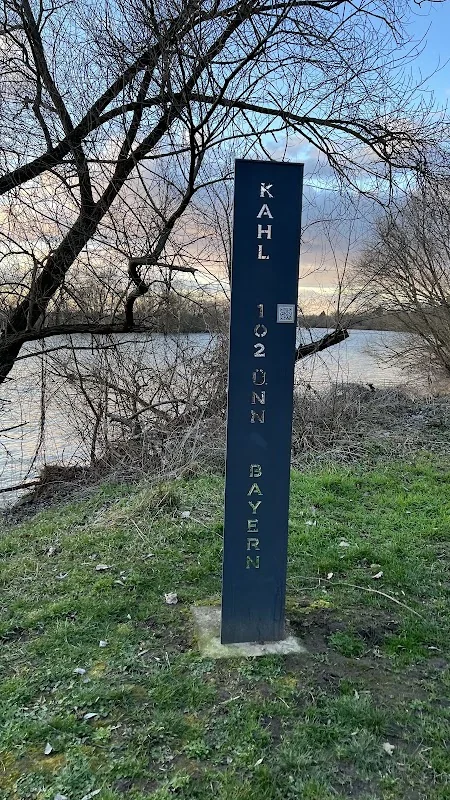
The deepest point of Bavaria is not a huge monument, but a geographical location with surprisingly much history, landscape, and local identity. In Kahl am Main, directly at the mouth of the Kahl into the Main, lies the lowest point of the Free State at around 102 meters above NHN. This is exactly what makes this place so interesting: it is a record point, but at the same time part of a vibrant river landscape that can be experienced very well on foot, by bike, or as part of a small excursion. Those looking for the deepest point of Bavaria Kahl am Main, for photos, or for a clear destination for a short detour will find here a combination of nature, local history, and an unusual geographical marker. The municipality itself lists the point among its attractions and highlights it as a special attraction. At the same time, it is situated in an environment characterized by the Main riverside path, Kahlaue, lakes, hiking trails, and other local highlights. This is precisely where the charm arises: the place is unspectacular in the best sense and gains impact precisely through its simplicity. It is not staged like an amusement park, but embedded in a real landscape space that tells the story of river courses, usage history, and regional self-awareness. ([kahl-main.de](https://www.kahl-main.de/seite/de/gemeinde/2443/-/Tiefster_Punkt_Bayerns.html?utm_source=openai))
Why the Deepest Point of Bavaria is in Kahl am Main
Geographically, the point is clear: the municipality of Kahl a. Main states that it lies 102 meters above sea level, and at the mouth of the Kahl is the lowest point of Bavaria. This fact is not just a nice footnote, but a real topic of interest for visitors who like records, borders, and special places. The mouth area is the key. Because here the course of the Kahl ends, which flows through the Kahlgrund into the Main. At exactly this point, a smaller river meets the larger stream, resulting in the lowest point in the Free State. The official municipal information also emphasizes that the mouth is not far from the decommissioned test power plant and that the riverbed has changed several times between 1900 and 1930. This combination of natural location and historical redesign makes the place so remarkable. The number 102 meters is therefore not just a data point, but an expression of a developed landscape that has changed over decades. So those looking for the deepest point of Bavaria are not just looking for a measurement value, but a place where geography becomes immediately visible. ([kahl-main.de](https://www.kahl-main.de/seite/de/gemeinde/2443/-/Tiefster_Punkt_Bayerns.html?utm_source=openai))
Also exciting is the historical context: the municipality explains that the Kahl once flowed around the Emma-Süd opencast mine in a large arc, which is now occupied by the Hornsee. In its natural state, it flowed north of the current mouth into the Main. Only later regulation of the river and the consequences of coal mining shaped the appearance that visitors experience today. This is precisely why the deepest point of Bavaria in Kahl am Main is not just a point on the map, but also a small lesson in regional environmental history. The location symbolizes the connection between people, river, and landscape: the place is defined by water, shaped by use, and consciously marked as a sight. This has great significance for local identity, as Kahl am Main has thus become known far beyond the municipal borders. The municipality explicitly lists the deepest point of Bavaria among the attractions, and BR Heimat also describes the mouth area of the Kahl as the deepest point of Bavaria. Thus, a clear consensus arises between municipal representation and public perception: those asking about the deepest point of Bavaria end up in Kahl am Main at the mouth of the Kahl. ([kahl-main.de](https://www.kahl-main.de/seite/de/gemeinde/2443/-/Tiefster_Punkt_Bayerns.html?utm_source=openai))
Access, Orientation, and Parking at the Kahl Mouth
Kahl am Main is well connected for access. In the citizens' brochure of the municipality, the A45 and A3 highways are mentioned; additionally, the brochure refers to train connections towards Frankfurt, Kahl, and Aschaffenburg as well as Hanau, Kahl, Alzenau, and Schöllkrippen. This is important for visitors because the deepest point of Bavaria is not a closed excursion operation with a ticket office and entrance, but a freely accessible place in the local and river area. Therefore, the way there usually leads through the local area, the train station, the campsite, or the Main riverside path. Those arriving by bike can orient themselves to the designated Main routes; those walking should best follow the river course and local signage. The municipality mentions the popular route of the Main bike and hiking path as well as the Kahltal-Spessart bike path as important connections along the Main. This creates simple orientation: Kahl am Main is accessible, the Kahl mouth is not hidden, and the way there fits well into a small day trip. ([kahl-main.de](https://www.kahl-main.de/datei/de/gemeinde/-/2944/extLink?utm_source=openai))
Regarding parking, the direct proximity to the camping and leisure area is helpful. The address Am Campingplatz 1, 63796 Kahl am Main is explicitly mentioned for car arrivals at the campsite, where the parking spaces of the campsite are also located. This is practical for visitors to the deepest point of Bavaria, as the mouth area and the Main riverside path can be easily accessed in this environment. Additionally, the municipality lists charging and starting points at the campsite, train station, Waldseehalle, and other places in the town in its brochure. Therefore, those wishing to explore the area leisurely should best plan with a little time and use one of the known starting points in the town. The advantage is clear: one does not have to search long, but can combine the excursion with a walk or a small bike ride. This also fits the structure of the place, which is characterized not by hectic traffic areas but by a rather flat, open, and easily accessible location by the Main. For many visitors, this is the most pleasant way to experience the deepest point of Bavaria: without much effort, but with a good overview and direct proximity to nature. ([campingplatz-kahl.de](https://campingplatz-kahl.de/zufahrtbeschreibung/?utm_source=openai))
Photos, Walks, and the Marked Point at the Main Riverside Path
Those looking for photos of the deepest point of Bavaria usually do not want a spectacular stage set, but rather a clear, credible place. The Kahl mouth offers exactly that. The point is marked on the Main riverside path, making it particularly attractive for short walks. Komoot explicitly describes the spot as marked on this route. This makes sense, as the surroundings do not thrive on monumentality but on their calm, open river landscape. Such places are often the strongest for photos: the water, the shore zones, the flat landscape, and the clear geographical statement together create an image that is immediately understandable. Additionally, the municipality has included the place itself in its list of attractions, signaling that it is not a random point but a consciously communicated excursion destination. Therefore, those arriving with a camera or smartphone will find less the classic postcard motif but rather an authentic record image that works through its simplicity. This is almost ideal for social media, as the place can be quickly narrated: Here lies the deepest point of Bavaria. ([komoot.com](https://www.komoot.com/de-de/highlight/265055?utm_source=openai))
As a walking destination, the place also works very well because the Main riverside path is not just a short access but part of a larger network of paths. The municipality describes a popular cycling and hiking path along the Main and additionally refers to the Kahltal-Spessart bike path. The flat circular hiking paths in the town and the location at the banks make the area ideal for a quiet round without sporting pressure. This is particularly pleasant for families, older visitors, or anyone who has little time but still wants to see an unusual place. The images then almost create themselves: a river, a shore, a marked spot, and the idea that Bavaria is deepest right here. Thus, those photographing the point are not just photographing landscape but also a regional peculiarity. This combination is rare. Most record locations are heavily altered or hard to reach, but at the Kahl mouth, the opposite is true. The point is accessible, understandable, and embedded in a real leisure landscape. This is precisely why the small detour from pure factual knowledge to real experience on site is worthwhile. ([kahl-main.de](https://www.kahl-main.de/seite/de/gemeinde/90/-/Wandern_und_Radeln.html?utm_source=openai))
History of the Kahl Mouth and the Changed River Landscape
The current location of the deepest point of Bavaria is closely linked to the history of river regulation. The municipality of Kahl explains that the riverbed of the Kahl was changed several times between 1900 and 1930 because coal mining forced interventions in the landscape. The Kahl flowed around the Emma-Süd opencast mine in a large arc, which is now occupied by the Hornsee. This means that the spot where we today locate the deepest point of Bavaria is the result of a long development in which water, resource extraction, and landscape reconstruction intertwined. Particularly interesting is that the Kahl flowed into the Main in its natural state north of the current mouth. The historical location was therefore different from today. This is precisely what makes the place so exciting for people interested in regional history. The spot is not only geographically deep but also historically deep, as it bears traces of an era when rivers were technically altered even more. Those visiting Kahl am Main therefore experience not just a record point but a small piece of environmental and settlement history of the Bavarian Untermain. ([kahl-main.de](https://www.kahl-main.de/seite/de/gemeinde/2443/-/Tiefster_Punkt_Bayerns.html?utm_source=openai))
The official description goes further and also names the Kahl regulation upstream as a reason why many mills had to cease operations. This is an important note, as it shows how closely the history of the place is linked to the use of water. Mills, river courses, lakes, pits, and later recreational use belong here in a common narrative thread. The deep point at the Main is thus part of a larger transformation: from a utilization landscape, it gradually became a recreational landscape. The municipality explicitly describes the Kahl lakes as relics of the brown coal era, which today form a widely known recreational area. At calm waters like Christner See, Hornsee, Schlossparksee, and Gustavsee, a remarkable fauna and flora have developed. This connection between past and present is characteristic of the place. The deepest point of Bavaria is therefore not alone, but in the midst of an environment shaped by earlier interventions, later renaturation, and today's recreational use. This is precisely why the record point becomes more than just a number: it becomes an access point into the history of the landscape at the Untermain. ([kahl-main.de](https://www.kahl-main.de/seite/de/gemeinde/90/-/Wandern_und_Radeln.html?utm_source=openai))
Hiking, Cycling, and Leisure around Kahl am Main
Those visiting the deepest point of Bavaria quickly realize that it fits into a larger recreational landscape. The municipality mentions five flat circular hiking paths that invite for walks and hikes. Additionally, there is the popular cycling path along the Main, which runs from Mainz through Frankfurt, Miltenberg, and Würzburg to Volkach, as well as the Kahltal-Spessart bike path, which leads through the towns of the Kahlgrund to Lohr am Main. This is particularly attractive for visitors because the record location is thus integrated into a real network of paths. One can therefore not only briefly stop at the Kahl mouth but easily combine the visit with another round. The flat topography makes the area pleasant: no steep ascent, no complicated path guidance, but open shores, wide views, and good combination options. This fits search queries like hiking, cycling, or excursion destination, as the place provides the practical answer. Those seeking relaxed movement rather than a sporting challenge find exactly what they are looking for here. ([kahl-main.de](https://www.kahl-main.de/seite/de/gemeinde/90/-/Wandern_und_Radeln.html?utm_source=openai))
The municipality also describes the Kahl lakes as a recreational area where swimming, sailing, and fishing are possible, and where a remarkable fauna and flora have been preserved. This is important because it places the deepest point of Bavaria in a holistic local context. Kahl am Main is not just a municipality with a special elevation date but also a place with a campsite, Main connection, water areas, nature, and active leisure culture. Additionally, there are further offers such as mini-golf, indoor swimming pool, boules court, canoeing, and various club activities that the municipality lists on its leisure page. Visitors coming for the record point can therefore easily stay longer and use the place as a small excursion focus. Particularly appealing is the mix of nature and infrastructure: one is quickly at the water, but just as quickly back in the town, at the train station, or in the camping area. This makes Kahl am Main a pleasant destination for day visitors, cyclists, and families. The deepest point of Bavaria is thus not an isolated place but a starting or ending point for a whole range of activities that build around the Main, the Kahlaue, and the lake landscape. ([kahl-main.de](https://www.kahl-main.de/seite/de/gemeinde/90/-/Wandern_und_Radeln.html?utm_source=openai))
Sights in the Town: Water Tower, Town Hall, and More
While the deepest point of Bavaria is the most well-known record motif, Kahl am Main has other attractions that round off the visit. Particularly striking is, according to the municipality, the ensemble of the 27-meter-high water tower built in 1931 and the sandstone building of the town hall, which was built in 1830 as a customs house at the border of Bavaria. These two buildings tell in different ways about the development of the place. The water tower stands for technical modernization and became the town's focal point, while the town hall, as a former customs house, recalls the historical function of the border and the administrative everyday life of past times. Additionally, there are further attractions such as the Catholic parish church of St. Margareta, the Kreuzkirche in Bauhaus style, the late Baroque Emmerichshofen Castle, and the stone baking oven. Therefore, those visiting the deepest point of Bavaria can easily draw a connection from nature to local history. This is particularly interesting for visitors who are not just looking for a photo spot but also want to understand how the place has grown. The municipality lists the deepest point itself along with these attractions, which further confirms its position in the local visit program. ([kahl-main.de](https://www.kahl-main.de/seite/de/gemeinde/014%3A81/-/Sehenswuerdigkeiten.html?utm_source=openai))
Particularly helpful is that the attractions in Kahl are not only spaced apart but form a coherent picture. The water tower, the town hall, and the other historical points are located in such a way that a small round trip can be easily combined. This quickly turns the visit to the deepest point into a compact town visit with several stages. The municipality also refers to the cultural and historical embedding of the place, for example, through local history, cultural hiking paths, and the development of community life. This creates a complete impression of Kahl am Main: a place by the river, with technical history, border history, recreational value, and a very special geographical record. Therefore, those searching for the deepest point of Bavaria receive more than just a measurement point. They get a place that makes its location visible, explains its history, and forms a surprisingly rounded excursion destination with further attractions. This is precisely why the visit is worthwhile not only for photos but also for anyone who wants to connect regional peculiarities with a short walk, a bike tour, or a small cultural stop. ([kahl-main.de](https://www.kahl-main.de/seite/de/gemeinde/014%3A81/-/Sehenswuerdigkeiten.html?utm_source=openai))
Sources:
- Municipality of Kahl a.Main – Deepest Point of Bavaria ([kahl-main.de](https://www.kahl-main.de/seite/de/gemeinde/2443/-/Tiefster_Punkt_Bayerns.html?utm_source=openai))
- Municipality of Kahl a.Main – Hiking & Cycling ([kahl-main.de](https://www.kahl-main.de/seite/de/gemeinde/90/-/Wandern_und_Radeln.html?utm_source=openai))
- Municipality of Kahl a.Main – Attractions in Kahl ([kahl-main.de](https://www.kahl-main.de/seite/de/gemeinde/014%3A81/-/Sehenswuerdigkeiten.html?utm_source=openai))
- Municipality of Kahl a.Main – Citizens' Brochure / Kahl am Main in Brief ([kahl-main.de](https://www.kahl-main.de/datei/de/gemeinde/-/2944/extLink?utm_source=openai))
- BR Heimat – Twelve O'Clock Ringing Kahl am Main ([br.de](https://www.br.de/radio/br-heimat/sendungen/zwoelfuhrlaeuten/unterfranken/xxuhr-kahl-unterfranken104.html?utm_source=openai))
- Komoot – Deepest Point of Bavaria ([komoot.com](https://www.komoot.com/de-de/highlight/265055?utm_source=openai))
Mehr anzeigenWeniger anzeigen
Deepest Point of Bavaria | Kahl am Main & Photos
The deepest point of Bavaria is not a huge monument, but a geographical location with surprisingly much history, landscape, and local identity. In Kahl am Main, directly at the mouth of the Kahl into the Main, lies the lowest point of the Free State at around 102 meters above NHN. This is exactly what makes this place so interesting: it is a record point, but at the same time part of a vibrant river landscape that can be experienced very well on foot, by bike, or as part of a small excursion. Those looking for the deepest point of Bavaria Kahl am Main, for photos, or for a clear destination for a short detour will find here a combination of nature, local history, and an unusual geographical marker. The municipality itself lists the point among its attractions and highlights it as a special attraction. At the same time, it is situated in an environment characterized by the Main riverside path, Kahlaue, lakes, hiking trails, and other local highlights. This is precisely where the charm arises: the place is unspectacular in the best sense and gains impact precisely through its simplicity. It is not staged like an amusement park, but embedded in a real landscape space that tells the story of river courses, usage history, and regional self-awareness. ([kahl-main.de](https://www.kahl-main.de/seite/de/gemeinde/2443/-/Tiefster_Punkt_Bayerns.html?utm_source=openai))
Why the Deepest Point of Bavaria is in Kahl am Main
Geographically, the point is clear: the municipality of Kahl a. Main states that it lies 102 meters above sea level, and at the mouth of the Kahl is the lowest point of Bavaria. This fact is not just a nice footnote, but a real topic of interest for visitors who like records, borders, and special places. The mouth area is the key. Because here the course of the Kahl ends, which flows through the Kahlgrund into the Main. At exactly this point, a smaller river meets the larger stream, resulting in the lowest point in the Free State. The official municipal information also emphasizes that the mouth is not far from the decommissioned test power plant and that the riverbed has changed several times between 1900 and 1930. This combination of natural location and historical redesign makes the place so remarkable. The number 102 meters is therefore not just a data point, but an expression of a developed landscape that has changed over decades. So those looking for the deepest point of Bavaria are not just looking for a measurement value, but a place where geography becomes immediately visible. ([kahl-main.de](https://www.kahl-main.de/seite/de/gemeinde/2443/-/Tiefster_Punkt_Bayerns.html?utm_source=openai))
Also exciting is the historical context: the municipality explains that the Kahl once flowed around the Emma-Süd opencast mine in a large arc, which is now occupied by the Hornsee. In its natural state, it flowed north of the current mouth into the Main. Only later regulation of the river and the consequences of coal mining shaped the appearance that visitors experience today. This is precisely why the deepest point of Bavaria in Kahl am Main is not just a point on the map, but also a small lesson in regional environmental history. The location symbolizes the connection between people, river, and landscape: the place is defined by water, shaped by use, and consciously marked as a sight. This has great significance for local identity, as Kahl am Main has thus become known far beyond the municipal borders. The municipality explicitly lists the deepest point of Bavaria among the attractions, and BR Heimat also describes the mouth area of the Kahl as the deepest point of Bavaria. Thus, a clear consensus arises between municipal representation and public perception: those asking about the deepest point of Bavaria end up in Kahl am Main at the mouth of the Kahl. ([kahl-main.de](https://www.kahl-main.de/seite/de/gemeinde/2443/-/Tiefster_Punkt_Bayerns.html?utm_source=openai))
Access, Orientation, and Parking at the Kahl Mouth
Kahl am Main is well connected for access. In the citizens' brochure of the municipality, the A45 and A3 highways are mentioned; additionally, the brochure refers to train connections towards Frankfurt, Kahl, and Aschaffenburg as well as Hanau, Kahl, Alzenau, and Schöllkrippen. This is important for visitors because the deepest point of Bavaria is not a closed excursion operation with a ticket office and entrance, but a freely accessible place in the local and river area. Therefore, the way there usually leads through the local area, the train station, the campsite, or the Main riverside path. Those arriving by bike can orient themselves to the designated Main routes; those walking should best follow the river course and local signage. The municipality mentions the popular route of the Main bike and hiking path as well as the Kahltal-Spessart bike path as important connections along the Main. This creates simple orientation: Kahl am Main is accessible, the Kahl mouth is not hidden, and the way there fits well into a small day trip. ([kahl-main.de](https://www.kahl-main.de/datei/de/gemeinde/-/2944/extLink?utm_source=openai))
Regarding parking, the direct proximity to the camping and leisure area is helpful. The address Am Campingplatz 1, 63796 Kahl am Main is explicitly mentioned for car arrivals at the campsite, where the parking spaces of the campsite are also located. This is practical for visitors to the deepest point of Bavaria, as the mouth area and the Main riverside path can be easily accessed in this environment. Additionally, the municipality lists charging and starting points at the campsite, train station, Waldseehalle, and other places in the town in its brochure. Therefore, those wishing to explore the area leisurely should best plan with a little time and use one of the known starting points in the town. The advantage is clear: one does not have to search long, but can combine the excursion with a walk or a small bike ride. This also fits the structure of the place, which is characterized not by hectic traffic areas but by a rather flat, open, and easily accessible location by the Main. For many visitors, this is the most pleasant way to experience the deepest point of Bavaria: without much effort, but with a good overview and direct proximity to nature. ([campingplatz-kahl.de](https://campingplatz-kahl.de/zufahrtbeschreibung/?utm_source=openai))
Photos, Walks, and the Marked Point at the Main Riverside Path
Those looking for photos of the deepest point of Bavaria usually do not want a spectacular stage set, but rather a clear, credible place. The Kahl mouth offers exactly that. The point is marked on the Main riverside path, making it particularly attractive for short walks. Komoot explicitly describes the spot as marked on this route. This makes sense, as the surroundings do not thrive on monumentality but on their calm, open river landscape. Such places are often the strongest for photos: the water, the shore zones, the flat landscape, and the clear geographical statement together create an image that is immediately understandable. Additionally, the municipality has included the place itself in its list of attractions, signaling that it is not a random point but a consciously communicated excursion destination. Therefore, those arriving with a camera or smartphone will find less the classic postcard motif but rather an authentic record image that works through its simplicity. This is almost ideal for social media, as the place can be quickly narrated: Here lies the deepest point of Bavaria. ([komoot.com](https://www.komoot.com/de-de/highlight/265055?utm_source=openai))
As a walking destination, the place also works very well because the Main riverside path is not just a short access but part of a larger network of paths. The municipality describes a popular cycling and hiking path along the Main and additionally refers to the Kahltal-Spessart bike path. The flat circular hiking paths in the town and the location at the banks make the area ideal for a quiet round without sporting pressure. This is particularly pleasant for families, older visitors, or anyone who has little time but still wants to see an unusual place. The images then almost create themselves: a river, a shore, a marked spot, and the idea that Bavaria is deepest right here. Thus, those photographing the point are not just photographing landscape but also a regional peculiarity. This combination is rare. Most record locations are heavily altered or hard to reach, but at the Kahl mouth, the opposite is true. The point is accessible, understandable, and embedded in a real leisure landscape. This is precisely why the small detour from pure factual knowledge to real experience on site is worthwhile. ([kahl-main.de](https://www.kahl-main.de/seite/de/gemeinde/90/-/Wandern_und_Radeln.html?utm_source=openai))
History of the Kahl Mouth and the Changed River Landscape
The current location of the deepest point of Bavaria is closely linked to the history of river regulation. The municipality of Kahl explains that the riverbed of the Kahl was changed several times between 1900 and 1930 because coal mining forced interventions in the landscape. The Kahl flowed around the Emma-Süd opencast mine in a large arc, which is now occupied by the Hornsee. This means that the spot where we today locate the deepest point of Bavaria is the result of a long development in which water, resource extraction, and landscape reconstruction intertwined. Particularly interesting is that the Kahl flowed into the Main in its natural state north of the current mouth. The historical location was therefore different from today. This is precisely what makes the place so exciting for people interested in regional history. The spot is not only geographically deep but also historically deep, as it bears traces of an era when rivers were technically altered even more. Those visiting Kahl am Main therefore experience not just a record point but a small piece of environmental and settlement history of the Bavarian Untermain. ([kahl-main.de](https://www.kahl-main.de/seite/de/gemeinde/2443/-/Tiefster_Punkt_Bayerns.html?utm_source=openai))
The official description goes further and also names the Kahl regulation upstream as a reason why many mills had to cease operations. This is an important note, as it shows how closely the history of the place is linked to the use of water. Mills, river courses, lakes, pits, and later recreational use belong here in a common narrative thread. The deep point at the Main is thus part of a larger transformation: from a utilization landscape, it gradually became a recreational landscape. The municipality explicitly describes the Kahl lakes as relics of the brown coal era, which today form a widely known recreational area. At calm waters like Christner See, Hornsee, Schlossparksee, and Gustavsee, a remarkable fauna and flora have developed. This connection between past and present is characteristic of the place. The deepest point of Bavaria is therefore not alone, but in the midst of an environment shaped by earlier interventions, later renaturation, and today's recreational use. This is precisely why the record point becomes more than just a number: it becomes an access point into the history of the landscape at the Untermain. ([kahl-main.de](https://www.kahl-main.de/seite/de/gemeinde/90/-/Wandern_und_Radeln.html?utm_source=openai))
Hiking, Cycling, and Leisure around Kahl am Main
Those visiting the deepest point of Bavaria quickly realize that it fits into a larger recreational landscape. The municipality mentions five flat circular hiking paths that invite for walks and hikes. Additionally, there is the popular cycling path along the Main, which runs from Mainz through Frankfurt, Miltenberg, and Würzburg to Volkach, as well as the Kahltal-Spessart bike path, which leads through the towns of the Kahlgrund to Lohr am Main. This is particularly attractive for visitors because the record location is thus integrated into a real network of paths. One can therefore not only briefly stop at the Kahl mouth but easily combine the visit with another round. The flat topography makes the area pleasant: no steep ascent, no complicated path guidance, but open shores, wide views, and good combination options. This fits search queries like hiking, cycling, or excursion destination, as the place provides the practical answer. Those seeking relaxed movement rather than a sporting challenge find exactly what they are looking for here. ([kahl-main.de](https://www.kahl-main.de/seite/de/gemeinde/90/-/Wandern_und_Radeln.html?utm_source=openai))
The municipality also describes the Kahl lakes as a recreational area where swimming, sailing, and fishing are possible, and where a remarkable fauna and flora have been preserved. This is important because it places the deepest point of Bavaria in a holistic local context. Kahl am Main is not just a municipality with a special elevation date but also a place with a campsite, Main connection, water areas, nature, and active leisure culture. Additionally, there are further offers such as mini-golf, indoor swimming pool, boules court, canoeing, and various club activities that the municipality lists on its leisure page. Visitors coming for the record point can therefore easily stay longer and use the place as a small excursion focus. Particularly appealing is the mix of nature and infrastructure: one is quickly at the water, but just as quickly back in the town, at the train station, or in the camping area. This makes Kahl am Main a pleasant destination for day visitors, cyclists, and families. The deepest point of Bavaria is thus not an isolated place but a starting or ending point for a whole range of activities that build around the Main, the Kahlaue, and the lake landscape. ([kahl-main.de](https://www.kahl-main.de/seite/de/gemeinde/90/-/Wandern_und_Radeln.html?utm_source=openai))
Sights in the Town: Water Tower, Town Hall, and More
While the deepest point of Bavaria is the most well-known record motif, Kahl am Main has other attractions that round off the visit. Particularly striking is, according to the municipality, the ensemble of the 27-meter-high water tower built in 1931 and the sandstone building of the town hall, which was built in 1830 as a customs house at the border of Bavaria. These two buildings tell in different ways about the development of the place. The water tower stands for technical modernization and became the town's focal point, while the town hall, as a former customs house, recalls the historical function of the border and the administrative everyday life of past times. Additionally, there are further attractions such as the Catholic parish church of St. Margareta, the Kreuzkirche in Bauhaus style, the late Baroque Emmerichshofen Castle, and the stone baking oven. Therefore, those visiting the deepest point of Bavaria can easily draw a connection from nature to local history. This is particularly interesting for visitors who are not just looking for a photo spot but also want to understand how the place has grown. The municipality lists the deepest point itself along with these attractions, which further confirms its position in the local visit program. ([kahl-main.de](https://www.kahl-main.de/seite/de/gemeinde/014%3A81/-/Sehenswuerdigkeiten.html?utm_source=openai))
Particularly helpful is that the attractions in Kahl are not only spaced apart but form a coherent picture. The water tower, the town hall, and the other historical points are located in such a way that a small round trip can be easily combined. This quickly turns the visit to the deepest point into a compact town visit with several stages. The municipality also refers to the cultural and historical embedding of the place, for example, through local history, cultural hiking paths, and the development of community life. This creates a complete impression of Kahl am Main: a place by the river, with technical history, border history, recreational value, and a very special geographical record. Therefore, those searching for the deepest point of Bavaria receive more than just a measurement point. They get a place that makes its location visible, explains its history, and forms a surprisingly rounded excursion destination with further attractions. This is precisely why the visit is worthwhile not only for photos but also for anyone who wants to connect regional peculiarities with a short walk, a bike tour, or a small cultural stop. ([kahl-main.de](https://www.kahl-main.de/seite/de/gemeinde/014%3A81/-/Sehenswuerdigkeiten.html?utm_source=openai))
Sources:
- Municipality of Kahl a.Main – Deepest Point of Bavaria ([kahl-main.de](https://www.kahl-main.de/seite/de/gemeinde/2443/-/Tiefster_Punkt_Bayerns.html?utm_source=openai))
- Municipality of Kahl a.Main – Hiking & Cycling ([kahl-main.de](https://www.kahl-main.de/seite/de/gemeinde/90/-/Wandern_und_Radeln.html?utm_source=openai))
- Municipality of Kahl a.Main – Attractions in Kahl ([kahl-main.de](https://www.kahl-main.de/seite/de/gemeinde/014%3A81/-/Sehenswuerdigkeiten.html?utm_source=openai))
- Municipality of Kahl a.Main – Citizens' Brochure / Kahl am Main in Brief ([kahl-main.de](https://www.kahl-main.de/datei/de/gemeinde/-/2944/extLink?utm_source=openai))
- BR Heimat – Twelve O'Clock Ringing Kahl am Main ([br.de](https://www.br.de/radio/br-heimat/sendungen/zwoelfuhrlaeuten/unterfranken/xxuhr-kahl-unterfranken104.html?utm_source=openai))
- Komoot – Deepest Point of Bavaria ([komoot.com](https://www.komoot.com/de-de/highlight/265055?utm_source=openai))
Deepest Point of Bavaria | Kahl am Main & Photos
The deepest point of Bavaria is not a huge monument, but a geographical location with surprisingly much history, landscape, and local identity. In Kahl am Main, directly at the mouth of the Kahl into the Main, lies the lowest point of the Free State at around 102 meters above NHN. This is exactly what makes this place so interesting: it is a record point, but at the same time part of a vibrant river landscape that can be experienced very well on foot, by bike, or as part of a small excursion. Those looking for the deepest point of Bavaria Kahl am Main, for photos, or for a clear destination for a short detour will find here a combination of nature, local history, and an unusual geographical marker. The municipality itself lists the point among its attractions and highlights it as a special attraction. At the same time, it is situated in an environment characterized by the Main riverside path, Kahlaue, lakes, hiking trails, and other local highlights. This is precisely where the charm arises: the place is unspectacular in the best sense and gains impact precisely through its simplicity. It is not staged like an amusement park, but embedded in a real landscape space that tells the story of river courses, usage history, and regional self-awareness. ([kahl-main.de](https://www.kahl-main.de/seite/de/gemeinde/2443/-/Tiefster_Punkt_Bayerns.html?utm_source=openai))
Why the Deepest Point of Bavaria is in Kahl am Main
Geographically, the point is clear: the municipality of Kahl a. Main states that it lies 102 meters above sea level, and at the mouth of the Kahl is the lowest point of Bavaria. This fact is not just a nice footnote, but a real topic of interest for visitors who like records, borders, and special places. The mouth area is the key. Because here the course of the Kahl ends, which flows through the Kahlgrund into the Main. At exactly this point, a smaller river meets the larger stream, resulting in the lowest point in the Free State. The official municipal information also emphasizes that the mouth is not far from the decommissioned test power plant and that the riverbed has changed several times between 1900 and 1930. This combination of natural location and historical redesign makes the place so remarkable. The number 102 meters is therefore not just a data point, but an expression of a developed landscape that has changed over decades. So those looking for the deepest point of Bavaria are not just looking for a measurement value, but a place where geography becomes immediately visible. ([kahl-main.de](https://www.kahl-main.de/seite/de/gemeinde/2443/-/Tiefster_Punkt_Bayerns.html?utm_source=openai))
Also exciting is the historical context: the municipality explains that the Kahl once flowed around the Emma-Süd opencast mine in a large arc, which is now occupied by the Hornsee. In its natural state, it flowed north of the current mouth into the Main. Only later regulation of the river and the consequences of coal mining shaped the appearance that visitors experience today. This is precisely why the deepest point of Bavaria in Kahl am Main is not just a point on the map, but also a small lesson in regional environmental history. The location symbolizes the connection between people, river, and landscape: the place is defined by water, shaped by use, and consciously marked as a sight. This has great significance for local identity, as Kahl am Main has thus become known far beyond the municipal borders. The municipality explicitly lists the deepest point of Bavaria among the attractions, and BR Heimat also describes the mouth area of the Kahl as the deepest point of Bavaria. Thus, a clear consensus arises between municipal representation and public perception: those asking about the deepest point of Bavaria end up in Kahl am Main at the mouth of the Kahl. ([kahl-main.de](https://www.kahl-main.de/seite/de/gemeinde/2443/-/Tiefster_Punkt_Bayerns.html?utm_source=openai))
Access, Orientation, and Parking at the Kahl Mouth
Kahl am Main is well connected for access. In the citizens' brochure of the municipality, the A45 and A3 highways are mentioned; additionally, the brochure refers to train connections towards Frankfurt, Kahl, and Aschaffenburg as well as Hanau, Kahl, Alzenau, and Schöllkrippen. This is important for visitors because the deepest point of Bavaria is not a closed excursion operation with a ticket office and entrance, but a freely accessible place in the local and river area. Therefore, the way there usually leads through the local area, the train station, the campsite, or the Main riverside path. Those arriving by bike can orient themselves to the designated Main routes; those walking should best follow the river course and local signage. The municipality mentions the popular route of the Main bike and hiking path as well as the Kahltal-Spessart bike path as important connections along the Main. This creates simple orientation: Kahl am Main is accessible, the Kahl mouth is not hidden, and the way there fits well into a small day trip. ([kahl-main.de](https://www.kahl-main.de/datei/de/gemeinde/-/2944/extLink?utm_source=openai))
Regarding parking, the direct proximity to the camping and leisure area is helpful. The address Am Campingplatz 1, 63796 Kahl am Main is explicitly mentioned for car arrivals at the campsite, where the parking spaces of the campsite are also located. This is practical for visitors to the deepest point of Bavaria, as the mouth area and the Main riverside path can be easily accessed in this environment. Additionally, the municipality lists charging and starting points at the campsite, train station, Waldseehalle, and other places in the town in its brochure. Therefore, those wishing to explore the area leisurely should best plan with a little time and use one of the known starting points in the town. The advantage is clear: one does not have to search long, but can combine the excursion with a walk or a small bike ride. This also fits the structure of the place, which is characterized not by hectic traffic areas but by a rather flat, open, and easily accessible location by the Main. For many visitors, this is the most pleasant way to experience the deepest point of Bavaria: without much effort, but with a good overview and direct proximity to nature. ([campingplatz-kahl.de](https://campingplatz-kahl.de/zufahrtbeschreibung/?utm_source=openai))
Photos, Walks, and the Marked Point at the Main Riverside Path
Those looking for photos of the deepest point of Bavaria usually do not want a spectacular stage set, but rather a clear, credible place. The Kahl mouth offers exactly that. The point is marked on the Main riverside path, making it particularly attractive for short walks. Komoot explicitly describes the spot as marked on this route. This makes sense, as the surroundings do not thrive on monumentality but on their calm, open river landscape. Such places are often the strongest for photos: the water, the shore zones, the flat landscape, and the clear geographical statement together create an image that is immediately understandable. Additionally, the municipality has included the place itself in its list of attractions, signaling that it is not a random point but a consciously communicated excursion destination. Therefore, those arriving with a camera or smartphone will find less the classic postcard motif but rather an authentic record image that works through its simplicity. This is almost ideal for social media, as the place can be quickly narrated: Here lies the deepest point of Bavaria. ([komoot.com](https://www.komoot.com/de-de/highlight/265055?utm_source=openai))
As a walking destination, the place also works very well because the Main riverside path is not just a short access but part of a larger network of paths. The municipality describes a popular cycling and hiking path along the Main and additionally refers to the Kahltal-Spessart bike path. The flat circular hiking paths in the town and the location at the banks make the area ideal for a quiet round without sporting pressure. This is particularly pleasant for families, older visitors, or anyone who has little time but still wants to see an unusual place. The images then almost create themselves: a river, a shore, a marked spot, and the idea that Bavaria is deepest right here. Thus, those photographing the point are not just photographing landscape but also a regional peculiarity. This combination is rare. Most record locations are heavily altered or hard to reach, but at the Kahl mouth, the opposite is true. The point is accessible, understandable, and embedded in a real leisure landscape. This is precisely why the small detour from pure factual knowledge to real experience on site is worthwhile. ([kahl-main.de](https://www.kahl-main.de/seite/de/gemeinde/90/-/Wandern_und_Radeln.html?utm_source=openai))
History of the Kahl Mouth and the Changed River Landscape
The current location of the deepest point of Bavaria is closely linked to the history of river regulation. The municipality of Kahl explains that the riverbed of the Kahl was changed several times between 1900 and 1930 because coal mining forced interventions in the landscape. The Kahl flowed around the Emma-Süd opencast mine in a large arc, which is now occupied by the Hornsee. This means that the spot where we today locate the deepest point of Bavaria is the result of a long development in which water, resource extraction, and landscape reconstruction intertwined. Particularly interesting is that the Kahl flowed into the Main in its natural state north of the current mouth. The historical location was therefore different from today. This is precisely what makes the place so exciting for people interested in regional history. The spot is not only geographically deep but also historically deep, as it bears traces of an era when rivers were technically altered even more. Those visiting Kahl am Main therefore experience not just a record point but a small piece of environmental and settlement history of the Bavarian Untermain. ([kahl-main.de](https://www.kahl-main.de/seite/de/gemeinde/2443/-/Tiefster_Punkt_Bayerns.html?utm_source=openai))
The official description goes further and also names the Kahl regulation upstream as a reason why many mills had to cease operations. This is an important note, as it shows how closely the history of the place is linked to the use of water. Mills, river courses, lakes, pits, and later recreational use belong here in a common narrative thread. The deep point at the Main is thus part of a larger transformation: from a utilization landscape, it gradually became a recreational landscape. The municipality explicitly describes the Kahl lakes as relics of the brown coal era, which today form a widely known recreational area. At calm waters like Christner See, Hornsee, Schlossparksee, and Gustavsee, a remarkable fauna and flora have developed. This connection between past and present is characteristic of the place. The deepest point of Bavaria is therefore not alone, but in the midst of an environment shaped by earlier interventions, later renaturation, and today's recreational use. This is precisely why the record point becomes more than just a number: it becomes an access point into the history of the landscape at the Untermain. ([kahl-main.de](https://www.kahl-main.de/seite/de/gemeinde/90/-/Wandern_und_Radeln.html?utm_source=openai))
Hiking, Cycling, and Leisure around Kahl am Main
Those visiting the deepest point of Bavaria quickly realize that it fits into a larger recreational landscape. The municipality mentions five flat circular hiking paths that invite for walks and hikes. Additionally, there is the popular cycling path along the Main, which runs from Mainz through Frankfurt, Miltenberg, and Würzburg to Volkach, as well as the Kahltal-Spessart bike path, which leads through the towns of the Kahlgrund to Lohr am Main. This is particularly attractive for visitors because the record location is thus integrated into a real network of paths. One can therefore not only briefly stop at the Kahl mouth but easily combine the visit with another round. The flat topography makes the area pleasant: no steep ascent, no complicated path guidance, but open shores, wide views, and good combination options. This fits search queries like hiking, cycling, or excursion destination, as the place provides the practical answer. Those seeking relaxed movement rather than a sporting challenge find exactly what they are looking for here. ([kahl-main.de](https://www.kahl-main.de/seite/de/gemeinde/90/-/Wandern_und_Radeln.html?utm_source=openai))
The municipality also describes the Kahl lakes as a recreational area where swimming, sailing, and fishing are possible, and where a remarkable fauna and flora have been preserved. This is important because it places the deepest point of Bavaria in a holistic local context. Kahl am Main is not just a municipality with a special elevation date but also a place with a campsite, Main connection, water areas, nature, and active leisure culture. Additionally, there are further offers such as mini-golf, indoor swimming pool, boules court, canoeing, and various club activities that the municipality lists on its leisure page. Visitors coming for the record point can therefore easily stay longer and use the place as a small excursion focus. Particularly appealing is the mix of nature and infrastructure: one is quickly at the water, but just as quickly back in the town, at the train station, or in the camping area. This makes Kahl am Main a pleasant destination for day visitors, cyclists, and families. The deepest point of Bavaria is thus not an isolated place but a starting or ending point for a whole range of activities that build around the Main, the Kahlaue, and the lake landscape. ([kahl-main.de](https://www.kahl-main.de/seite/de/gemeinde/90/-/Wandern_und_Radeln.html?utm_source=openai))
Sights in the Town: Water Tower, Town Hall, and More
While the deepest point of Bavaria is the most well-known record motif, Kahl am Main has other attractions that round off the visit. Particularly striking is, according to the municipality, the ensemble of the 27-meter-high water tower built in 1931 and the sandstone building of the town hall, which was built in 1830 as a customs house at the border of Bavaria. These two buildings tell in different ways about the development of the place. The water tower stands for technical modernization and became the town's focal point, while the town hall, as a former customs house, recalls the historical function of the border and the administrative everyday life of past times. Additionally, there are further attractions such as the Catholic parish church of St. Margareta, the Kreuzkirche in Bauhaus style, the late Baroque Emmerichshofen Castle, and the stone baking oven. Therefore, those visiting the deepest point of Bavaria can easily draw a connection from nature to local history. This is particularly interesting for visitors who are not just looking for a photo spot but also want to understand how the place has grown. The municipality lists the deepest point itself along with these attractions, which further confirms its position in the local visit program. ([kahl-main.de](https://www.kahl-main.de/seite/de/gemeinde/014%3A81/-/Sehenswuerdigkeiten.html?utm_source=openai))
Particularly helpful is that the attractions in Kahl are not only spaced apart but form a coherent picture. The water tower, the town hall, and the other historical points are located in such a way that a small round trip can be easily combined. This quickly turns the visit to the deepest point into a compact town visit with several stages. The municipality also refers to the cultural and historical embedding of the place, for example, through local history, cultural hiking paths, and the development of community life. This creates a complete impression of Kahl am Main: a place by the river, with technical history, border history, recreational value, and a very special geographical record. Therefore, those searching for the deepest point of Bavaria receive more than just a measurement point. They get a place that makes its location visible, explains its history, and forms a surprisingly rounded excursion destination with further attractions. This is precisely why the visit is worthwhile not only for photos but also for anyone who wants to connect regional peculiarities with a short walk, a bike tour, or a small cultural stop. ([kahl-main.de](https://www.kahl-main.de/seite/de/gemeinde/014%3A81/-/Sehenswuerdigkeiten.html?utm_source=openai))
Sources:
- Municipality of Kahl a.Main – Deepest Point of Bavaria ([kahl-main.de](https://www.kahl-main.de/seite/de/gemeinde/2443/-/Tiefster_Punkt_Bayerns.html?utm_source=openai))
- Municipality of Kahl a.Main – Hiking & Cycling ([kahl-main.de](https://www.kahl-main.de/seite/de/gemeinde/90/-/Wandern_und_Radeln.html?utm_source=openai))
- Municipality of Kahl a.Main – Attractions in Kahl ([kahl-main.de](https://www.kahl-main.de/seite/de/gemeinde/014%3A81/-/Sehenswuerdigkeiten.html?utm_source=openai))
- Municipality of Kahl a.Main – Citizens' Brochure / Kahl am Main in Brief ([kahl-main.de](https://www.kahl-main.de/datei/de/gemeinde/-/2944/extLink?utm_source=openai))
- BR Heimat – Twelve O'Clock Ringing Kahl am Main ([br.de](https://www.br.de/radio/br-heimat/sendungen/zwoelfuhrlaeuten/unterfranken/xxuhr-kahl-unterfranken104.html?utm_source=openai))
- Komoot – Deepest Point of Bavaria ([komoot.com](https://www.komoot.com/de-de/highlight/265055?utm_source=openai))

Frequently Asked Questions
Reviews
No reviews found