
Ebertbrücke, Aschaffenburg
Ebertbrücke, 63741 Aschaffenburg, Germany
Ebert Bridge | Aschaffenburg & Access/Parking
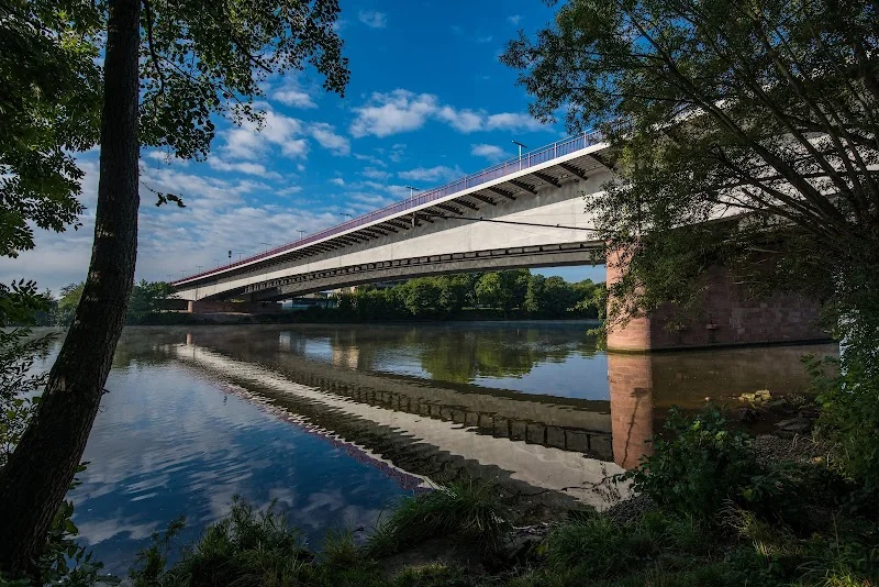
The Ebert Bridge is one of the most important inner-city crossings of the Main in Aschaffenburg, connecting the city center with the district of Leider along Federal Highway 26. For residents, commuters, cyclists, and pedestrians, it is a daily waypoint – and at the same time a beautiful location to gaze over the wide Main and experience the striking panorama with Johannisburg Castle. The bridge today consists of two parallel structures: an older superstructure from the 1960s and a complementary second structure that was put into operation in 2008. Sidewalks and bike paths on both sides ensure safe crossings alongside the four-lane motor vehicle traffic. Thanks to its central location, the bridge connects directly to the modernly designed castle waterfront and the promenades along the Main; those arriving here can reach the historic center with museums, dining, and shopping options in just a few minutes. Access is provided via the B26 and the city ring road, with parking options available through a dense network of parking garages guided by the city's parking guidance system. This page consolidates verified facts about access and parking, the construction history and special features of the Ebert Bridge, as well as useful tips for everyone using the bridge on foot, by bike, or by car.
Access to Ebert Bridge Aschaffenburg (B26, City Center & City Ring)
As part of the B26, the Ebert Bridge is directly integrated into the regional road network. From the west and east, you generally follow the signs for “B26/Aschaffenburg Center.” The federal highway runs through the city area over the ring and crosses the Main via the Ebert Bridge. Those coming from the city center reach the ramps and junctions of the bridge via Hanauer Straße and Schillerstraße; from the south (castle waterfront), the access is connected via the nearby riverside roads with clear signage. The Aschaffenburg city ring then distributes traffic further towards Damm, Schweinheim, Nilkheim, and the industrial areas. For navigation devices, the recommended destination is “Ebert Bridge, 63741 Aschaffenburg.” For cyclists and pedestrians, the access paths are clearly marked: Side paths run along both sides of the bridge, connecting to the waterfront promenade and the Main cycle path. From the district of Leider, one can quickly reach the bridge by following the B26; from the city center, the crossings at Hanauer Straße and Schillerstraße provide safe crossings. Buses from the Aschaffenburg public transport operate frequently over the ring; several lines serve stops in the vicinity of the bridge ramps, making the combination of public transport and a short walk to the bridge convenient. During peak traffic times, there may be heavier traffic on the ring and at the bridgehead; especially then, it is worth checking the current information from the city and – in case of measures on federal roads – from the State Building Authority Aschaffenburg. For access from the surrounding area: The B26 connects Aschaffenburg with Darmstadt, Dieburg, Großostheim, and the Maintal; those coming from the A3 should follow the exits to the city and quickly switch to the B26. Thanks to its central location, city center destinations can be reached from the bridge in just a few minutes, whether by car, bike, or on foot – an advantage for appointments, shopping trips, or evening strolls by the river.
Parking at the Ebert Bridge: Parking Garages & Parking Guidance System
Parking around the Ebert Bridge is easy to plan, as Aschaffenburg has a dense network of parking garages and uses a dynamic parking guidance system. Those choosing the bridge as a starting point for the old town, the castle area, or the riverside will find several sensible options in the immediate vicinity. The City Gallery parking garage is particularly large, with around 1,700 parking spaces; it is only a few minutes' walk from the northern bridgehead and is accessible even outside of store opening hours. The underground garage at the town hall near the castle square is also conveniently located – ideal if you want to combine a walk across the bridge with a visit to Johannisburg Castle, museums, or events. Additionally, for access from certain districts, it is worth looking at the Luitpold parking garage on Friedrichstraße, which is well connected via the ring road. Depending on the time of day and occasion (weekly market, events, construction sites), the occupancy is distributed among the garages; the parking guidance system shows available capacities in real-time and indicates the fastest route to the nearest free parking garage. For visitors who want to leave their car parked for a longer period – for example, for a combined city and riverside walk – it may be worthwhile to park further outside and walk or take the bus the last part. This keeps the riverside area more relaxed, and you can already enjoy the walk to the bridge along the Main. Tip for families: Those with strollers, scooters, or balance bikes benefit from the convenient access points on both sides of the bridge and the barrier-friendly riverside paths; the stairs and ramps are wide and clear. Always check the maximum clearance height and payment options when entering parking garages. In Aschaffenburg, the public utilities operate several parking garages and underground garages; the rates are transparently displayed citywide on their respective websites or signage. With a glance at the occupancy display, you can head directly to the appropriate entrance – saving time and avoiding unnecessary trips into the city center.
History and Construction of the Ebert Bridge: 1965 to Second Structure 2008
The Ebert Bridge is named in honor of the first President of the Weimar Republic, Friedrich Ebert. The first bridge structure over the Main as part of the B26 was opened in the mid-1960s. It provided the growing city with an efficient east-west connection, relieved previous crossings, and connected the newly structured traffic axes at that time. Technically, it is a road bridge with a total length of about 310 meters. The superstructure sequence is divided into spans of approximately 85 m, 138 m, and 87 m; together with the parallel second structure, this results in a total width of about 30 meters. The older and the younger bridge structure opened in 2008 are located directly next to each other; they divide the traffic flows into two lanes per direction and both offer lateral space for sidewalks and bike paths. With the addition in 2008, not only was the capacity increased, but a contemporary lighting and safety concept was also integrated. In the evening, the bridge is atmospherically illuminated, which improves orientation and accentuates the cityscape by the river. For shipping on the Main, the clearance height of the bridge is an important parameter; the section is indicated in the route atlas and in nautical information, and appropriate protective measures – such as a ship impact protection – ensure the safety of the waterway and the structure. The bridge crosses the Main at river kilometer nearly 85.9, thus relatively close to the mouth into the Rhine. The choice of location has always taken into account the interconnection with the city ring and the city center – a reason why the view from the bridge of the silhouette with Johannisburg Castle, the collegiate basilica, and the Main terraces is so impressive. The bridge also marks a milestone in urban development policy: it connects the city center with the further developed district of Leider located by the riverside. In the 2000s, planning and construction for the second bridge structure began; reports and technical publications document the work, the static design as a steel composite construction, and the traffic decongestion achieved by separating the directional lanes. Since then, the bridge has reliably managed everyday traffic – at the same time, it remains a prominent part of the Aschaffenburg cityscape as an engineering structure.
Walking and Cycling over the Ebert Bridge: Main Cycle Path, Safety, Views
Those using the Ebert Bridge without a car experience it as a pleasantly short, direct connection between both banks of the Main. On each side of the bridge, there are wide sidewalks and bike paths that are separated from motor traffic. This allows you to quickly reach the castle waterfront, the city center, and the castle square from the district of Leider; from the city, it is also easy to cross to the western bank with its residential areas, sports, and green spaces. The regional Main cycle path runs along both sides of the river; the Ebert Bridge is an important crossing point in the region. Between the neighboring Main crossings, there are no other inner-city bridges for several kilometers – accordingly, everyday and leisure cyclists frequently use the Ebert Bridge to switch banks. For cyclists: Ride defensively, keep a distance from the bridge railing, reduce speed in heavy foot traffic, and use the access and exit ramps with caution. The crossing is particularly appealing in the evening hours when Johannisburg Castle is bathed in warm light and the bridge lighting adds a subtle color accent. Along the southern bank, the upgraded castle waterfront features resting areas, a green promenade, and a new elevator that since 2025 improves barrier-free access from the waterfront to the castle garden. For families with children, the riverside sections offer play and discovery zones; benches and terraces invite you to linger. Those taking photographs will find quiet spots on the bridge and at the ramps with unobstructed views of the castle, collegiate basilica, and the river landscape. Please note: On the bridge and at its junctions, different modes of transport intersect; consideration and clear signals (bell, hand signals) prevent misunderstandings. In unfavorable weather – strong winds or slippery conditions – special caution is required; the railing offers protection, but speed should still be adjusted. For route planning, it is advisable to check for any detours on the Main cycle path in advance, such as during construction work on riverside paths; the city and tourist information sites publish timely notices and alternative routes.
Traffic & Safety: Closures, Accident Situations, and Current Notices
As a central crossing of the Main, the Ebert Bridge carries large traffic volumes throughout the day. This means: Maintenance, regular inspections, and occasional closures of individual lanes are part of safe operations. The State Building Authority Aschaffenburg is responsible for federal roads in the city area, which communicates planned work – from maintenance to special safety measures such as ship impact protection – in advance. The city also informs about interventions in traffic management. In the event of incidents – such as accidents – local media report promptly. For example, on May 9, 2025, there was a closure following a truck incident where spilled cooking oil required a longer cleaning; the affected stretch extended from the bridge up to the B8. Further reports from recent years document individual traffic accidents on or in the immediate vicinity of the bridge (e.g., at Westring or at the junction of Hanauer Straße/Schillerstraße), which each caused local disruptions. These examples show: In case of disturbances, it is worth checking traffic reports for a quick detour to the Willigis or Konrad Adenauer Bridge. For pedestrians and cyclists, in many cases, the side paths remain passable even if motor vehicle lanes are restricted – official notices provide details. For emergency services from the fire department and rescue service, the ramps and staging areas at the bridge are important points; annual reports document operations that underline the good accessibility of the bridge. Those traveling by bike or on foot increase their own safety through visibility (light, reflectors), defensive behavior, and clear communication with other road users. Drivers should be particularly attentive when merging onto the ring, at the junction at the bridgehead, and when leaving the bridge. In general, it helps to plan a few extra minutes during peak traffic times – this keeps the drive over the Ebert Bridge relaxed, even if construction or cleaning work is underway.
Sights at the Riverside: Johannisburg Castle, Castle Waterfront & City Center
Crossing the Ebert Bridge is more than just a quick way from A to B: It is a short panorama tour over the Main. Dominating the riverside scenery is Johannisburg Castle – a significant Renaissance castle that today, with its collections, castle chapel, and castle garden, is one of the most important excursion destinations in the region. Right at the southern end of the bridge, the castle waterfront opens up with a promenade, seating steps, and sightlines to the river. Since the enhancement of the riverside area, the transition between the city and the Main has become significantly more attractive; new paths, greenery, and an elevator to the castle ensure short, convenient connections. Those strolling from the bridge towards the old town can reach the castle square, the collegiate museum, and other cultural sites in just a few minutes. The Main cycle path offers detours upstream and downstream; small play and relaxation areas along the river make the walk family-friendly. Around the bridge, you will also find cafés and dining options – ideal for a break with a view of the river. In the downstream direction, the modern urban landscape appears at the riverside; upstream, greenery, historical architecture, and the wide water surface frame the picture. Photographically interesting are the contrasts: red sandstone of the castle, the steel and concrete band of the bridge, reflections on the Main. Those who consciously change perspectives can descend from the bridge deck via the ramps to the low banks and discover new viewpoints there. Especially in the early evening hours, when the bridge lighting becomes visible and the castle shines, the atmosphere is particularly enchanting. For those interested in cultural history, it is worth taking a look at panels and publications that document the development of the castle surroundings, the riverside facilities, and the bridge crossings – they show how closely the history of the city is intertwined with the river and its crossings.
Comparison of the Main Bridges in Aschaffenburg: Ebert Bridge, Willigis Bridge & Konrad Adenauer Bridge
Aschaffenburg has three important road bridges over the Main: the Ebert Bridge, the Willigis Bridge, and the Konrad Adenauer Bridge. Together, they ensure the distribution of traffic between the city center, northern and southern districts, and the surrounding area. The Ebert Bridge plays a key role as it carries the B26 and is directly connected to the city ring. The Willigis Bridge complements the inner-city traffic relationships upstream and also opens up historical axes between the castle, old town, and the large landscape park Schönbusch. The Konrad Adenauer Bridge forms another efficient crossing and contributes to the decongestion on the ring. For outsiders, this trio is helpful: If there is a closure or restriction at one of the bridges, traffic can often be well redirected over one of the other two. For cyclists and pedestrians, multiple crossings also mean flexible route options – for example, for circular routes where one starts on one bridge, switches banks, and returns over another. Orientation is provided by maps and signage along the riverside paths as well as information on the city's tourist pages. Important for planning: The Main cycle path runs along the river; crossings therefore take place at selected bridges. Between some Main crossings, there are several kilometers of distance, which is why the Ebert Bridge remains a central crossing in the region. Those combining a bridge visit with a city tour ideally use the parking garages near the castle and the city or come directly by bike – this keeps the paths short, and the most beautiful viewpoints are close together.
Sources:
- Wikipedia – Friedrich Ebert Bridge (Aschaffenburg)
- brueckenweb – Ebert Bridge Aschaffenburg (Data Sheet, Construction 1965/Extension 2008)
- FAZ – Aschaffenburg: Four-lane over the Main (Planning/Extension, Target 2008)
- Wikipedia (EN) – Aschaffenburg (three Main bridges; new Ebert Bridge superstructure 2008)
- Structurae – Ebert Bridge (2008) – second lane with lighting concept
- State Building Authority Aschaffenburg – B26, Ship Impact Protection Ebert Bridge
- City Gallery Aschaffenburg – Parking Garage (approx. 1,700 parking spaces)
- Public Utilities Aschaffenburg – Parking (Parking Garages & Rates, Parking Guidance System)
- Tourist Information Aschaffenburg – Arrival & Parking Tickets (Parking Guidance System)
- Main Cycle Path – Detour Notice (Region Aschaffenburg/Kleinostheim)
- Castle Waterfront Aschaffenburg – Project Page (Enhancement of Riverside, New Paths)
- Castle Waterfront Aschaffenburg – Elevator to the Castle (in operation since 2025)
- Radio Primavera – Truck spills cooking oil: Ebert Bridge closed (09.05.2025)
- Main Echo – Accident on Westring causes massive traffic disruptions (12.11.2025, towards Ebert Bridge)
- Fire Department Aschaffenburg – Annual Report 2023 (Operations including at the Ebert Bridge)
Show moreShow less
Ebert Bridge | Aschaffenburg & Access/Parking
The Ebert Bridge is one of the most important inner-city crossings of the Main in Aschaffenburg, connecting the city center with the district of Leider along Federal Highway 26. For residents, commuters, cyclists, and pedestrians, it is a daily waypoint – and at the same time a beautiful location to gaze over the wide Main and experience the striking panorama with Johannisburg Castle. The bridge today consists of two parallel structures: an older superstructure from the 1960s and a complementary second structure that was put into operation in 2008. Sidewalks and bike paths on both sides ensure safe crossings alongside the four-lane motor vehicle traffic. Thanks to its central location, the bridge connects directly to the modernly designed castle waterfront and the promenades along the Main; those arriving here can reach the historic center with museums, dining, and shopping options in just a few minutes. Access is provided via the B26 and the city ring road, with parking options available through a dense network of parking garages guided by the city's parking guidance system. This page consolidates verified facts about access and parking, the construction history and special features of the Ebert Bridge, as well as useful tips for everyone using the bridge on foot, by bike, or by car.
Access to Ebert Bridge Aschaffenburg (B26, City Center & City Ring)
As part of the B26, the Ebert Bridge is directly integrated into the regional road network. From the west and east, you generally follow the signs for “B26/Aschaffenburg Center.” The federal highway runs through the city area over the ring and crosses the Main via the Ebert Bridge. Those coming from the city center reach the ramps and junctions of the bridge via Hanauer Straße and Schillerstraße; from the south (castle waterfront), the access is connected via the nearby riverside roads with clear signage. The Aschaffenburg city ring then distributes traffic further towards Damm, Schweinheim, Nilkheim, and the industrial areas. For navigation devices, the recommended destination is “Ebert Bridge, 63741 Aschaffenburg.” For cyclists and pedestrians, the access paths are clearly marked: Side paths run along both sides of the bridge, connecting to the waterfront promenade and the Main cycle path. From the district of Leider, one can quickly reach the bridge by following the B26; from the city center, the crossings at Hanauer Straße and Schillerstraße provide safe crossings. Buses from the Aschaffenburg public transport operate frequently over the ring; several lines serve stops in the vicinity of the bridge ramps, making the combination of public transport and a short walk to the bridge convenient. During peak traffic times, there may be heavier traffic on the ring and at the bridgehead; especially then, it is worth checking the current information from the city and – in case of measures on federal roads – from the State Building Authority Aschaffenburg. For access from the surrounding area: The B26 connects Aschaffenburg with Darmstadt, Dieburg, Großostheim, and the Maintal; those coming from the A3 should follow the exits to the city and quickly switch to the B26. Thanks to its central location, city center destinations can be reached from the bridge in just a few minutes, whether by car, bike, or on foot – an advantage for appointments, shopping trips, or evening strolls by the river.
Parking at the Ebert Bridge: Parking Garages & Parking Guidance System
Parking around the Ebert Bridge is easy to plan, as Aschaffenburg has a dense network of parking garages and uses a dynamic parking guidance system. Those choosing the bridge as a starting point for the old town, the castle area, or the riverside will find several sensible options in the immediate vicinity. The City Gallery parking garage is particularly large, with around 1,700 parking spaces; it is only a few minutes' walk from the northern bridgehead and is accessible even outside of store opening hours. The underground garage at the town hall near the castle square is also conveniently located – ideal if you want to combine a walk across the bridge with a visit to Johannisburg Castle, museums, or events. Additionally, for access from certain districts, it is worth looking at the Luitpold parking garage on Friedrichstraße, which is well connected via the ring road. Depending on the time of day and occasion (weekly market, events, construction sites), the occupancy is distributed among the garages; the parking guidance system shows available capacities in real-time and indicates the fastest route to the nearest free parking garage. For visitors who want to leave their car parked for a longer period – for example, for a combined city and riverside walk – it may be worthwhile to park further outside and walk or take the bus the last part. This keeps the riverside area more relaxed, and you can already enjoy the walk to the bridge along the Main. Tip for families: Those with strollers, scooters, or balance bikes benefit from the convenient access points on both sides of the bridge and the barrier-friendly riverside paths; the stairs and ramps are wide and clear. Always check the maximum clearance height and payment options when entering parking garages. In Aschaffenburg, the public utilities operate several parking garages and underground garages; the rates are transparently displayed citywide on their respective websites or signage. With a glance at the occupancy display, you can head directly to the appropriate entrance – saving time and avoiding unnecessary trips into the city center.
History and Construction of the Ebert Bridge: 1965 to Second Structure 2008
The Ebert Bridge is named in honor of the first President of the Weimar Republic, Friedrich Ebert. The first bridge structure over the Main as part of the B26 was opened in the mid-1960s. It provided the growing city with an efficient east-west connection, relieved previous crossings, and connected the newly structured traffic axes at that time. Technically, it is a road bridge with a total length of about 310 meters. The superstructure sequence is divided into spans of approximately 85 m, 138 m, and 87 m; together with the parallel second structure, this results in a total width of about 30 meters. The older and the younger bridge structure opened in 2008 are located directly next to each other; they divide the traffic flows into two lanes per direction and both offer lateral space for sidewalks and bike paths. With the addition in 2008, not only was the capacity increased, but a contemporary lighting and safety concept was also integrated. In the evening, the bridge is atmospherically illuminated, which improves orientation and accentuates the cityscape by the river. For shipping on the Main, the clearance height of the bridge is an important parameter; the section is indicated in the route atlas and in nautical information, and appropriate protective measures – such as a ship impact protection – ensure the safety of the waterway and the structure. The bridge crosses the Main at river kilometer nearly 85.9, thus relatively close to the mouth into the Rhine. The choice of location has always taken into account the interconnection with the city ring and the city center – a reason why the view from the bridge of the silhouette with Johannisburg Castle, the collegiate basilica, and the Main terraces is so impressive. The bridge also marks a milestone in urban development policy: it connects the city center with the further developed district of Leider located by the riverside. In the 2000s, planning and construction for the second bridge structure began; reports and technical publications document the work, the static design as a steel composite construction, and the traffic decongestion achieved by separating the directional lanes. Since then, the bridge has reliably managed everyday traffic – at the same time, it remains a prominent part of the Aschaffenburg cityscape as an engineering structure.
Walking and Cycling over the Ebert Bridge: Main Cycle Path, Safety, Views
Those using the Ebert Bridge without a car experience it as a pleasantly short, direct connection between both banks of the Main. On each side of the bridge, there are wide sidewalks and bike paths that are separated from motor traffic. This allows you to quickly reach the castle waterfront, the city center, and the castle square from the district of Leider; from the city, it is also easy to cross to the western bank with its residential areas, sports, and green spaces. The regional Main cycle path runs along both sides of the river; the Ebert Bridge is an important crossing point in the region. Between the neighboring Main crossings, there are no other inner-city bridges for several kilometers – accordingly, everyday and leisure cyclists frequently use the Ebert Bridge to switch banks. For cyclists: Ride defensively, keep a distance from the bridge railing, reduce speed in heavy foot traffic, and use the access and exit ramps with caution. The crossing is particularly appealing in the evening hours when Johannisburg Castle is bathed in warm light and the bridge lighting adds a subtle color accent. Along the southern bank, the upgraded castle waterfront features resting areas, a green promenade, and a new elevator that since 2025 improves barrier-free access from the waterfront to the castle garden. For families with children, the riverside sections offer play and discovery zones; benches and terraces invite you to linger. Those taking photographs will find quiet spots on the bridge and at the ramps with unobstructed views of the castle, collegiate basilica, and the river landscape. Please note: On the bridge and at its junctions, different modes of transport intersect; consideration and clear signals (bell, hand signals) prevent misunderstandings. In unfavorable weather – strong winds or slippery conditions – special caution is required; the railing offers protection, but speed should still be adjusted. For route planning, it is advisable to check for any detours on the Main cycle path in advance, such as during construction work on riverside paths; the city and tourist information sites publish timely notices and alternative routes.
Traffic & Safety: Closures, Accident Situations, and Current Notices
As a central crossing of the Main, the Ebert Bridge carries large traffic volumes throughout the day. This means: Maintenance, regular inspections, and occasional closures of individual lanes are part of safe operations. The State Building Authority Aschaffenburg is responsible for federal roads in the city area, which communicates planned work – from maintenance to special safety measures such as ship impact protection – in advance. The city also informs about interventions in traffic management. In the event of incidents – such as accidents – local media report promptly. For example, on May 9, 2025, there was a closure following a truck incident where spilled cooking oil required a longer cleaning; the affected stretch extended from the bridge up to the B8. Further reports from recent years document individual traffic accidents on or in the immediate vicinity of the bridge (e.g., at Westring or at the junction of Hanauer Straße/Schillerstraße), which each caused local disruptions. These examples show: In case of disturbances, it is worth checking traffic reports for a quick detour to the Willigis or Konrad Adenauer Bridge. For pedestrians and cyclists, in many cases, the side paths remain passable even if motor vehicle lanes are restricted – official notices provide details. For emergency services from the fire department and rescue service, the ramps and staging areas at the bridge are important points; annual reports document operations that underline the good accessibility of the bridge. Those traveling by bike or on foot increase their own safety through visibility (light, reflectors), defensive behavior, and clear communication with other road users. Drivers should be particularly attentive when merging onto the ring, at the junction at the bridgehead, and when leaving the bridge. In general, it helps to plan a few extra minutes during peak traffic times – this keeps the drive over the Ebert Bridge relaxed, even if construction or cleaning work is underway.
Sights at the Riverside: Johannisburg Castle, Castle Waterfront & City Center
Crossing the Ebert Bridge is more than just a quick way from A to B: It is a short panorama tour over the Main. Dominating the riverside scenery is Johannisburg Castle – a significant Renaissance castle that today, with its collections, castle chapel, and castle garden, is one of the most important excursion destinations in the region. Right at the southern end of the bridge, the castle waterfront opens up with a promenade, seating steps, and sightlines to the river. Since the enhancement of the riverside area, the transition between the city and the Main has become significantly more attractive; new paths, greenery, and an elevator to the castle ensure short, convenient connections. Those strolling from the bridge towards the old town can reach the castle square, the collegiate museum, and other cultural sites in just a few minutes. The Main cycle path offers detours upstream and downstream; small play and relaxation areas along the river make the walk family-friendly. Around the bridge, you will also find cafés and dining options – ideal for a break with a view of the river. In the downstream direction, the modern urban landscape appears at the riverside; upstream, greenery, historical architecture, and the wide water surface frame the picture. Photographically interesting are the contrasts: red sandstone of the castle, the steel and concrete band of the bridge, reflections on the Main. Those who consciously change perspectives can descend from the bridge deck via the ramps to the low banks and discover new viewpoints there. Especially in the early evening hours, when the bridge lighting becomes visible and the castle shines, the atmosphere is particularly enchanting. For those interested in cultural history, it is worth taking a look at panels and publications that document the development of the castle surroundings, the riverside facilities, and the bridge crossings – they show how closely the history of the city is intertwined with the river and its crossings.
Comparison of the Main Bridges in Aschaffenburg: Ebert Bridge, Willigis Bridge & Konrad Adenauer Bridge
Aschaffenburg has three important road bridges over the Main: the Ebert Bridge, the Willigis Bridge, and the Konrad Adenauer Bridge. Together, they ensure the distribution of traffic between the city center, northern and southern districts, and the surrounding area. The Ebert Bridge plays a key role as it carries the B26 and is directly connected to the city ring. The Willigis Bridge complements the inner-city traffic relationships upstream and also opens up historical axes between the castle, old town, and the large landscape park Schönbusch. The Konrad Adenauer Bridge forms another efficient crossing and contributes to the decongestion on the ring. For outsiders, this trio is helpful: If there is a closure or restriction at one of the bridges, traffic can often be well redirected over one of the other two. For cyclists and pedestrians, multiple crossings also mean flexible route options – for example, for circular routes where one starts on one bridge, switches banks, and returns over another. Orientation is provided by maps and signage along the riverside paths as well as information on the city's tourist pages. Important for planning: The Main cycle path runs along the river; crossings therefore take place at selected bridges. Between some Main crossings, there are several kilometers of distance, which is why the Ebert Bridge remains a central crossing in the region. Those combining a bridge visit with a city tour ideally use the parking garages near the castle and the city or come directly by bike – this keeps the paths short, and the most beautiful viewpoints are close together.
Sources:
- Wikipedia – Friedrich Ebert Bridge (Aschaffenburg)
- brueckenweb – Ebert Bridge Aschaffenburg (Data Sheet, Construction 1965/Extension 2008)
- FAZ – Aschaffenburg: Four-lane over the Main (Planning/Extension, Target 2008)
- Wikipedia (EN) – Aschaffenburg (three Main bridges; new Ebert Bridge superstructure 2008)
- Structurae – Ebert Bridge (2008) – second lane with lighting concept
- State Building Authority Aschaffenburg – B26, Ship Impact Protection Ebert Bridge
- City Gallery Aschaffenburg – Parking Garage (approx. 1,700 parking spaces)
- Public Utilities Aschaffenburg – Parking (Parking Garages & Rates, Parking Guidance System)
- Tourist Information Aschaffenburg – Arrival & Parking Tickets (Parking Guidance System)
- Main Cycle Path – Detour Notice (Region Aschaffenburg/Kleinostheim)
- Castle Waterfront Aschaffenburg – Project Page (Enhancement of Riverside, New Paths)
- Castle Waterfront Aschaffenburg – Elevator to the Castle (in operation since 2025)
- Radio Primavera – Truck spills cooking oil: Ebert Bridge closed (09.05.2025)
- Main Echo – Accident on Westring causes massive traffic disruptions (12.11.2025, towards Ebert Bridge)
- Fire Department Aschaffenburg – Annual Report 2023 (Operations including at the Ebert Bridge)
Frequently Asked Questions
Reviews
Martin Aleksander Janz
18. March 2019
Normal
Đức Minh Đinh
21. May 2024
The scenery is beautiful! You can see the Stiftsmuseum and the Johannesburg Palace.
Axel Mayer
24. October 2018
Aschaffenburg Castle is always worth a visit.
M Eisbär
26. August 2023
Beautiful view over the river and one side of the Johannisburg.
Thomas Schmitt
8. September 2019
A fantastic bridge, the best of the three Main bridges in Aschaffenburg. It consists of an older section and a parallel bridge built alongside it. The ring road runs over it.